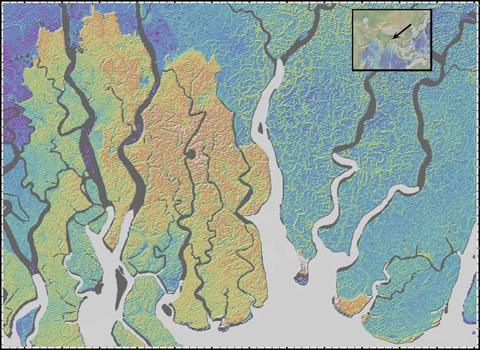
Bangladesh
Location: coast of Bangladesh, northern Bay of Bengal
Latitude: 22° N
Longitude: 90° E
Image Width: 80 km (50 miles)
Data: Shuttle Radar Topographic Mission (SRTM)
Description: This image shows the "Mouths of the Ganges", branches of the Ganges River, entering the Bay of Bengal. Traces of human agricultural activities, probably trees bordering farmed areas and drainage ditches can also be seen. |
|
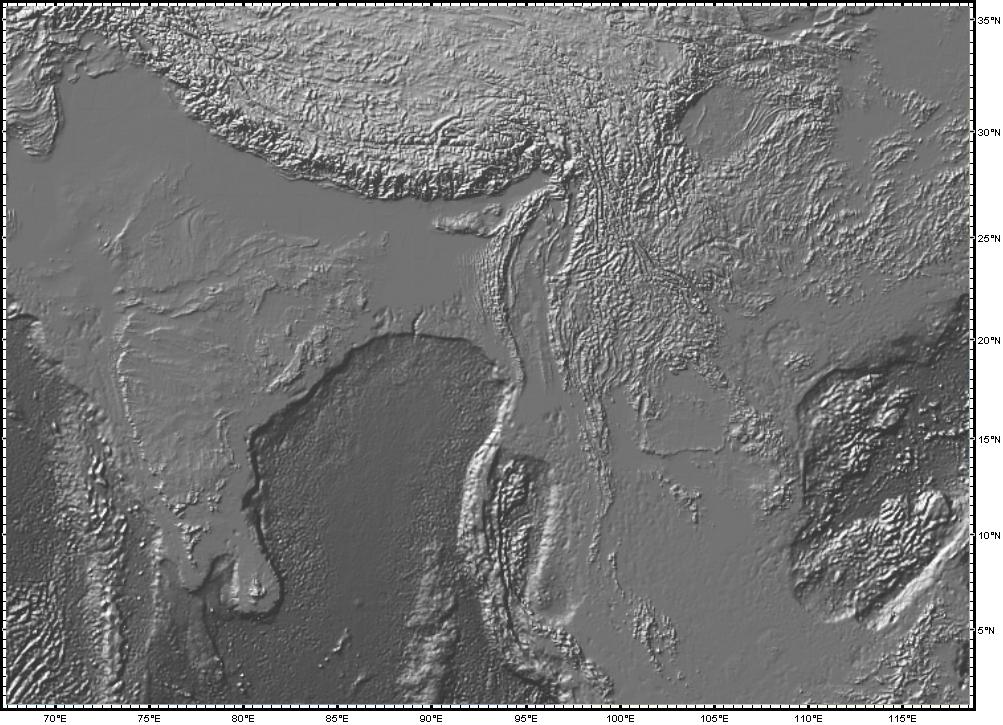
Bay of Bengal
Location: Bay of Bengal, northeastern Indian Ocean
Latitude: 2° to 34° N
Longitude: 65° to 115° E
Image Width: 5000 km (3000 miles)
Data: Shuttle Radar Topographic Mission (SRTM) and bathymetry from Smith & Sandwell
Description: This image shows the Bay of Bengal, the Indian subcontinent to the west and Indochina to the east. In the black and white image, the boundary between land and sea is blurred, emphasizing the roughness of the Himalaya mountains in the north and the undersea topography in the Andaman Sea near Indochina. It was along this plate boundary, near the tip of the island of Sumatra, that the December 26, 2005 earthquake ocurred, causing a major tsunami and loss of human life. In the color image, note the way the sediment, washed down from the Himalayan highlands by the Ganges River, has filled and smoothed the floor of the Bay of Bengal, forming the Bengal Fan. |
|
Dunes
Location: Taklimakan Desert, northwestern China
Latitude: 40° N
Longitude: 83° 30' E
Image Width: 135 km (85 miles)
Data: Shuttle Radar Topographic Mission (SRTM)
Description: This image shows sand dunes in the Taklamakan desert, the largest desert in central Asia and one of the largest sandy deserts in the world. Most of the dunes shown here are linear dunes, which form when sand is blown by winds which alternate in direction, often seasonally. This causes them to develop a meandering form and grow in length, unlike Barchan dunes, which form crescent shapes which can move across the landscape. Barchan dunes are formed when there is a single dominant wind direction. |
|
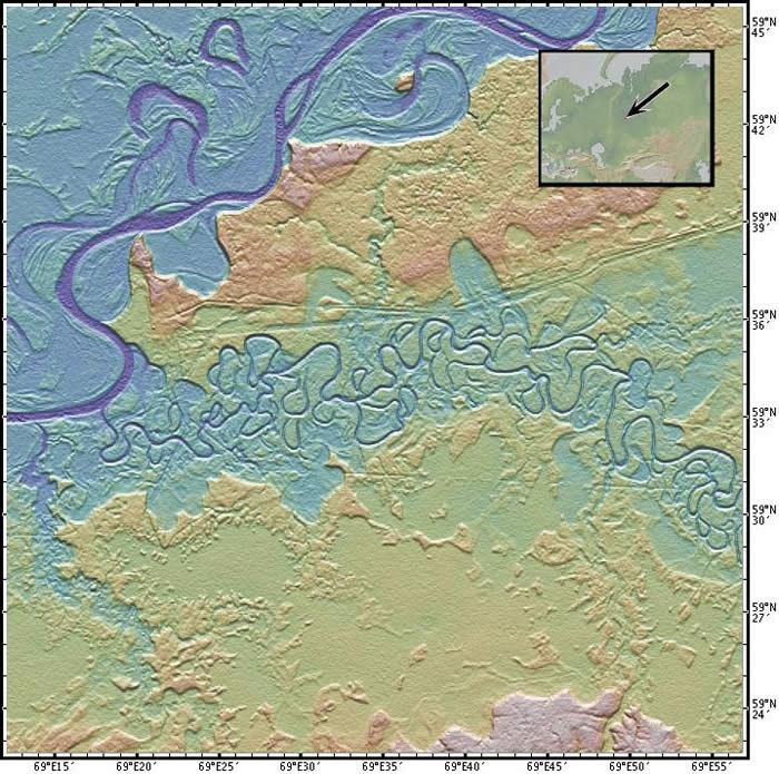
Meanders
Location: Irtysh River, about 200km east of the Ural Mts., Russia
Latitude: 59° 33' N
Longitude: 69° 30' E
Image Width: 45 km (27 miles)
Data: Shuttle Radar Topographic Mission (SRTM)
Description: River meanders are clearly seen here, as well as oxbow lakes formed when the river changed direction. Signs of human activity, such as road and railway clearings alongside the tributary stream, are visible as cuts in the tree canopy. |
|
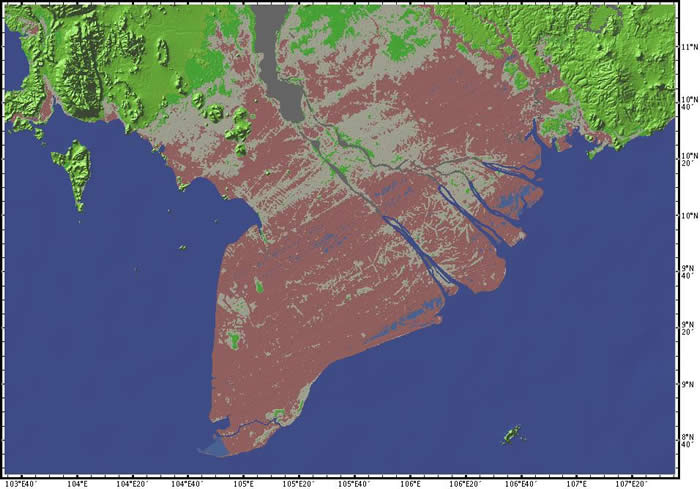
Mekong
Location: Delta of the Mekong River, Vietnam
Latitude: 10° N
Longitude: 10° E
Image Width: 440 km (270 miles)
Data: Shuttle Radar Topographic Mission (SRTM)
Description: The delta of the Mekong River, in southernmost Vietnam, is an important rice-growing area for Vietnam and home to twenty million people. Traces of the rice fields and roads can be seen. |
|
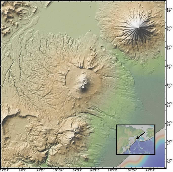
Volcanoes
Location: Kamchatka Peninsula, Russia
Latitude: 54° 36' N
Longitude: 160° 15' E
Image Width: 60 km (35 miles)
Data: Shuttle Radar Topographic Mission (SRTM)
Description: Volcanoes often occur at subduction zones, like these at the boundary of the Pacific and Eurasian plates on the Kamchatka peninsula in far eastern Siberia. The central volcano in the image appears to have a new, double cone forming in the center of the huge caldera of an older volcano. |
|
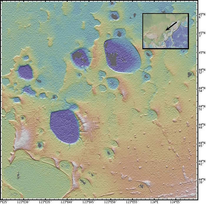
North China
Location: Jilin Province (formerly Manchuria), NE China
Latitude: 44° 54' N
Longitude: 123° 45' E
Image Width: 160 km (100 miles)
Data: Shuttle Radar Topographic Mission (SRTM)
Description: The unusual pattern is formed by shallow wetlands that are prime habitat for some of China's endangered cranes, such as the Red-crowned Crane. Signs of human activity, such as fields and roads or railways are visible here. |
|
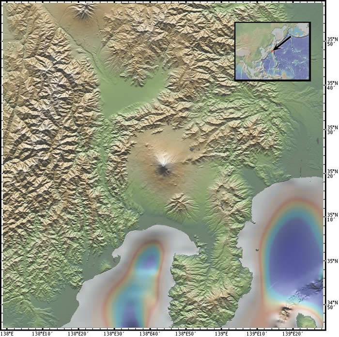
Mt. Fuji
Location: Mt. Fuji, Honshu Island, central Japan
Latitude: 35° 20' N
Longitude: 138° 40' E
Image Width: 135 km (85 miles)
Data: Shuttle Radar Topographic Mission (SRTM)
Description: Mt. Fuji, the famous volcano and icon of Japan, is seen in the center of this image. Its last eruption was in 1708. The perfect symmetry it shows today hides a complex geologic history. |
|


