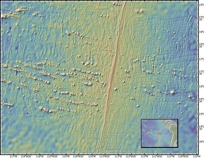
Seamounts
Location: southern East Pacific rise, South Pacific ocean
Latitude: 17° S
Longitude: 114° W
Image Width: 800km (500 miles)
Data: Shipboard multibeam bathymetry data provides detail
Description: This broad view of a section of the eastern central Pacific Ocean shows a multitude of seamounts on both sides of the East Pacific rise. Recent research has suggested that seamounts form near the ridge axis and are then carried away by the movement of the plates away from the spreading center. |
|
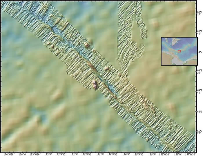
Pitman Fracture Zone
Location: Pitman fracture zone, South Pacific ocean
Latitude: 64° S
Longitude: 172° W
Image Width: 330km (200 miles)
Data: Shipboard multibeam bathymetry data
Description: Shipboard multibeam bathymetry provides this closeup view of the Pitman fracture zone on the ocean floor, where the Pacific Plate (upper right) meets the Antarctic Plate (lower left). This fracture zone is located in the far southern Pacific ocean, on the Pacific-Antarctic ridge between New Zealand and Ross Sea, Antarctica. |
|
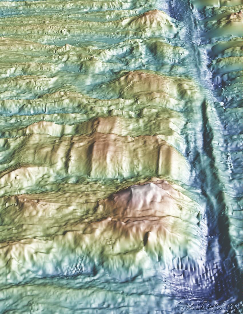
Kane Fracture Zone - 3D View
Location: Kane fracture zone, North Atlantic ocean
Latitude: 23° N
Longitude: 45° W
Image Width: 33km (20 miles)
Data: Shipboard multibeam bathymetry data
Description: The viewer is looking in a west-north-westerly direction along the transform fault in the Kane fracture zone, where the Africa Plate (upper right) and the North Atlantic Plate (left) are formed. This fracture zone is located in the central Atlantic ocean, on the slow-spreading Mid-Atlantic ridge between Africa and the Caribbean Sea. Shipboard multibeam bathymetry provides this closeup 3D view of the ocean floor; the checkerboard effect seen in part of the image is an artifact of the pattern made by the ships' tracks. |
|
East Pacific Rise 9° to 11° N - 3D View
Location: East Pacific Rise, Pacific ocean
Latitude: 9° to 11° N
Longitude: 104° W
Image Width: 250km (150 miles)
Data: Shipboard multibeam bathymetry data
Description: This is a perspective view looking north along the East Pacific Rise spreading center toward a prominent (dark blue = deeper) transform fault running to the east. The North American plate is to the right (east) of the rise. The Pacific plate is to the left (west). Shipboard multibeam bathymetry provides this closeup 3D view of the ocean floor. The seafloor seems out of focus in areas where there is no high-resolution bathymetry data available. |
|
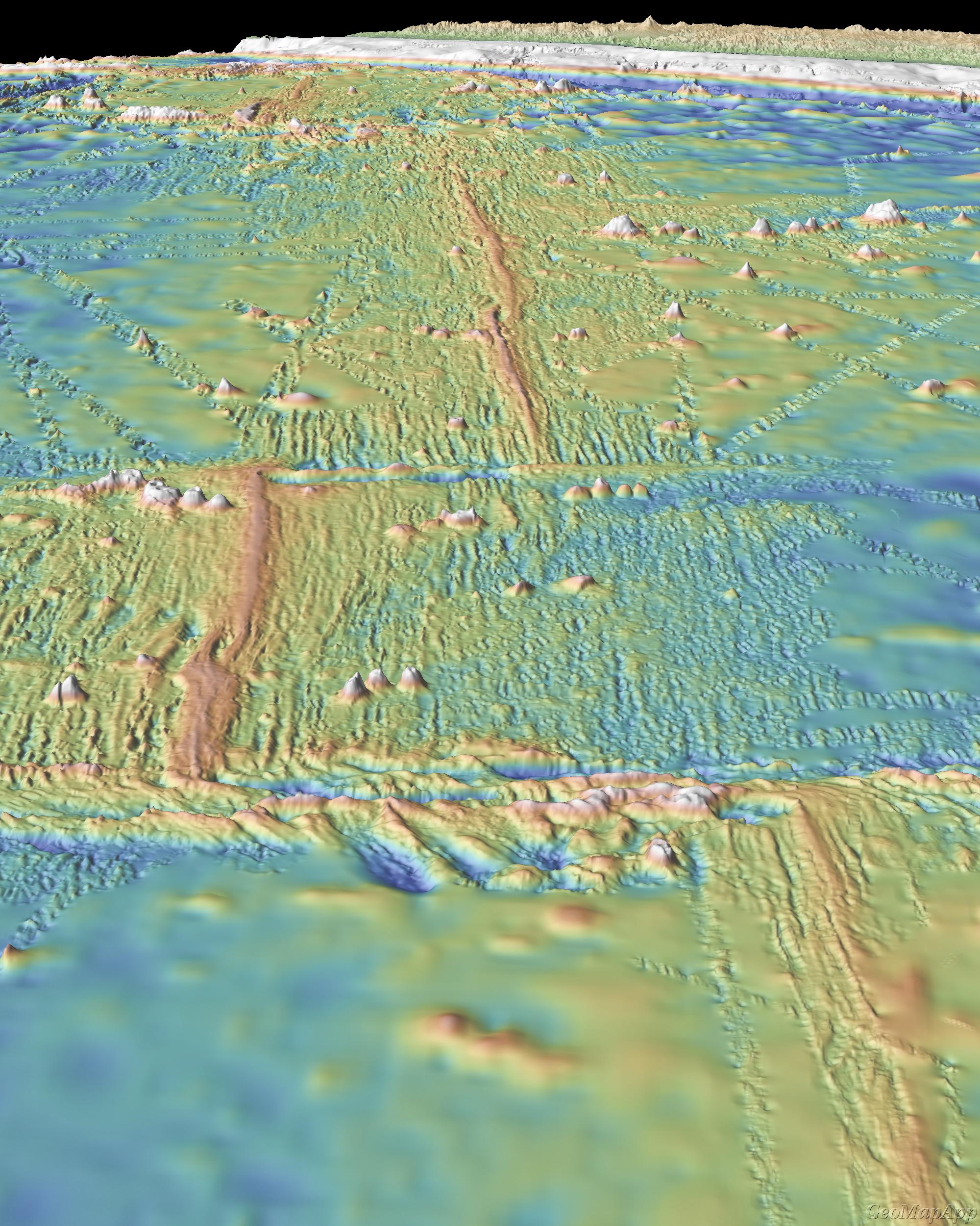
Along the East Pacific Rise from 7° N - 3D View
Location: East Pacific Rise, Pacific ocean
Latitude: 7° N
Longitude: 103° to 104° W
Image Width: 160 km (100 miles)
Data: Shipboard multibeam bathymetry data
Description: The viewer is looking north along the East Pacific Rise spreading center toward the mountains of the west coast of Mexico. Note the offsets in the spreading center. The North American plate is to the right (east) of the rise. The Pacific plate is to the left (west).
Shipboard multibeam bathymetry provides this closeup 3D view of the ocean floor. The seafloor seems out of focus in areas where there is no high-resolution bathymetry data available. |
|
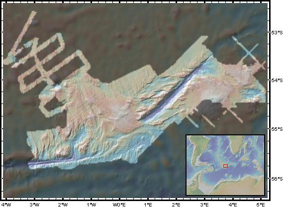
Bouvet Triple Junction
Location: midway between Antarctica, the Scotia Arc and Africa
Latitude: 54° S
Longitude: 1° W to 5° E
Image Width: 1000km (650 miles)
Data: Shipboard multibeam bathymetry
Description: The South American plate (to the left), the African plate (central and upper right), and Antarctic (lower part of image) lithospheric plates meet in the Bouvet Triple Junction located in the far South Atlantic ocean near the island of Bouvet. Italian multibeam survey data gives a high resolution view of this region; the area that was not surveyed is masked with a darker color.
Two sections of rift valley (deeper sections highlighted in dark blue) are clearly visible in this view.
Bouvet Island is a remote, uninhabited island containing only an unmanned weather-monitoring station. It belongs to Norway and is a declared nature preserve. |
|
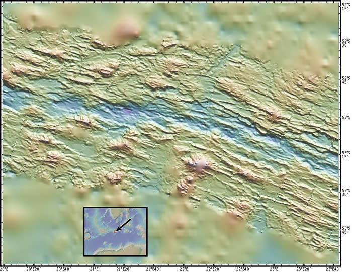
Southwest Indian Ridge
Location: Southwest Indian Ridge, between Antarctica and Africa
Latitude: 53° S
Longitude: 20° to 24° E
Image Width: 250km (150 miles)
Data: Shipboard multibeam bathymetry
Description: This image shows the deeper rift valley in blue, running east-west. The African Plate is to the north (top), and the Antarctic Plate is to the south (bottom). Where there is no multibeam data, the image appears fuzzy and out of focus. |
|


